
Forecast the rivers supplying the reservoirs
A compact benchmark set for each watershed, chosen for reservoir inflow relevance, distinct tributary coverage, and available daily observations.
Prepared October 20, 2026 · Observation snapshot: January 1, 1980–August 20, 2026.
Every primary choice is present in the outlet’s USGS NLDI upstream network. Station descriptions and operator sources support the inflow relationships. NLDI uses whole reaches/catchments, so membership alone is not proof of an exact on-channel position.
Recommended starting sets
| Watershed | Reservoir / outlet | Count | Primary gages (USGS IDs) |
|---|---|---|---|
| Verde | Horseshoe–Bartlett reservoir system | 1 | 09508500 |
| Upper Gila | San Carlos Reservoir / Coolidge Dam | 2 | 09466500, 09468500 |
| Salt + Tonto | Theodore Roosevelt Lake | 2 | 09498500, 09499000 |
| Upper Little Colorado | Lyman Lake | 1 | 09384000 |
| Upper San Juan + Piedra | Navajo Reservoir | 3 | 09346400, 09349800, 09354500 |
| Upper Green | Flaming Gorge; Fontenelle and Big Sandy upstream reservoir checks | 5 | 09217000, 09224700, 09229500, 09209400, 09213500 |
| Upper Gunnison | Blue Mesa Reservoir | 2 | 383103106594200, 09124500 |
| Blue River | Dillon Reservoir | 3 | 09046600, 09050100, 09047500 |
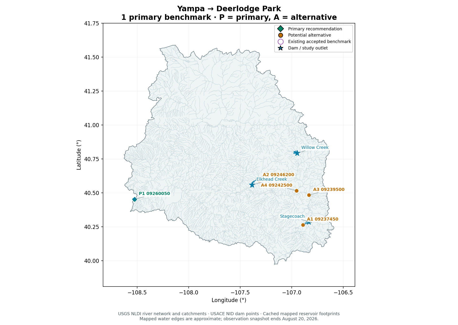
| Yampa | Deerlodge Park river outlet; Stagecoach and Elkhead reservoir alternatives | 1 | 09260050 |
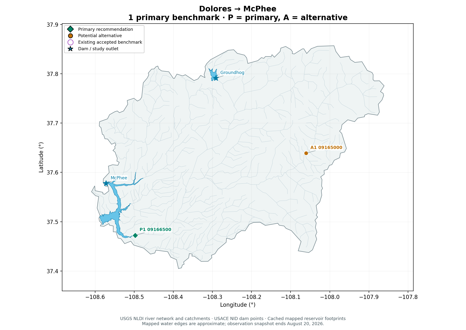
| Dolores | McPhee Reservoir | 1 | 09166500 |
Upper Green’s five include three Flaming Gorge inflow branches and two companions upstream of Fontenelle and Big Sandy reservoirs. Yampa is an outlet study; Stagecoach and Elkhead reservoir inflow alternatives appear in its section.
Snake River near Montezuma and Big Sandy near Farson are seasonal targets with missing winter observations. Four primary April–July seasons are incomplete in the cache: Salt River 2025 (121/122 days), Verde 2026 (120/122), Little Colorado above Lyman 2026 (121/122), and Little Snake 2026 (112/122). Keep daily observations where available; these seasons lack a strict complete seasonal-volume score.
Distance to a dam can be large even for a gage close to the reservoir’s upstream water edge. All tabulated distances are straight-line estimates, not river travel distances. Mapped reservoir edges are undated and vary with water level.
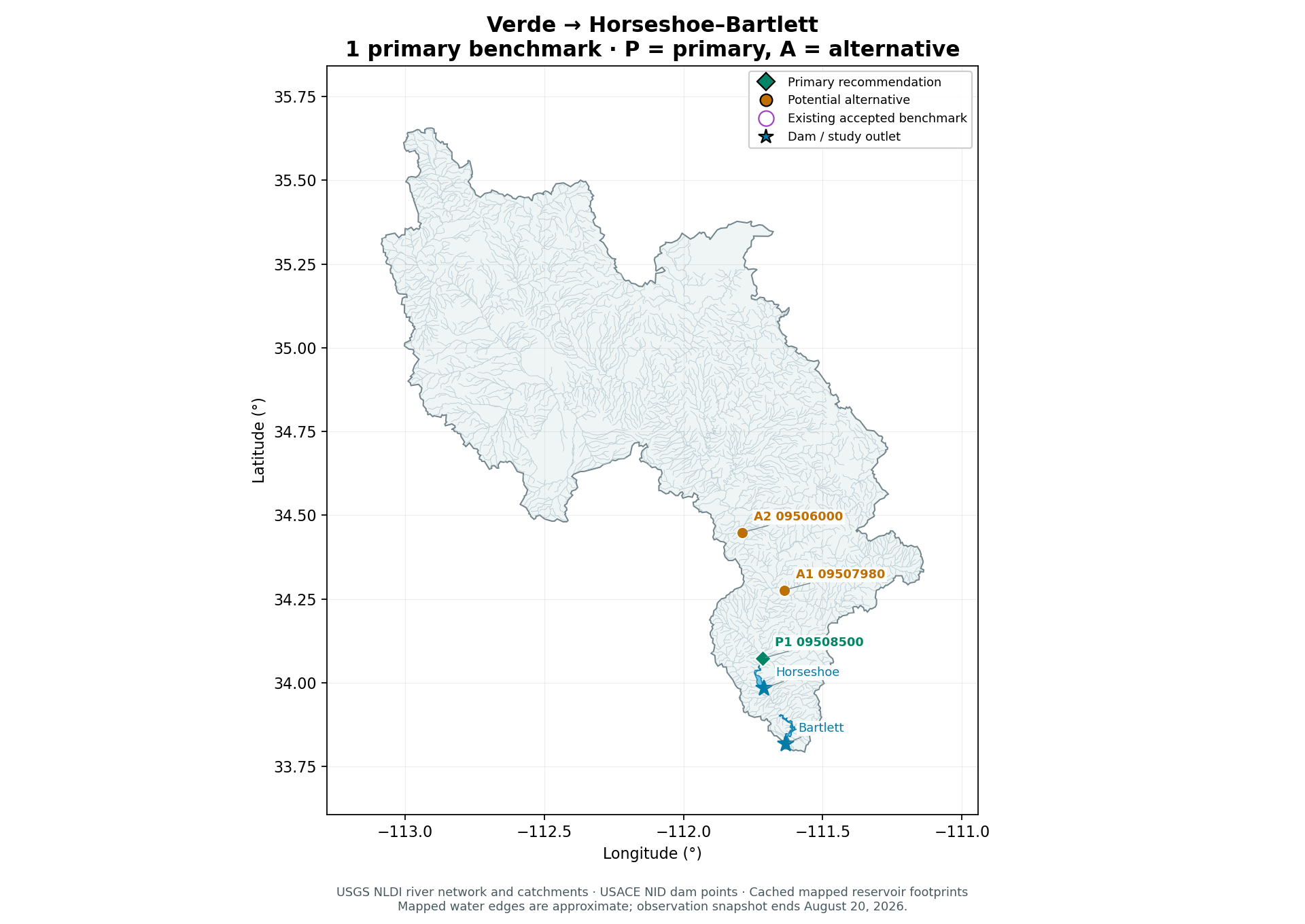
Verde
Horseshoe–Bartlett reservoir system
One well-placed combined mainstem inflow benchmark is sufficient for the initial reservoir-focused comparison because the major upstream tributaries have already merged. Additional tributary targets answer diagnostic questions rather than filling an independent reservoir arm.
| Key | Gage | 2023–24 | 2025–Aug 20, 2026 | Apr–Jul 2025 | Apr–Jul 2026 | Straight-line distances |
|---|---|---|---|---|---|---|
| P1 | USGS-09508500VERDE RVR BLW TANGLE CREEK, ABV HORSESHOE DAM, AZ | 731/731 | 593/597 | 122/122 | 120/122 | 2.6 km to Horseshoe29.4 km to study dam / outlet |
| A1 | USGS-09507980EAST VERDE RIVER NEAR CHILDS, AZ | 731/731 | 597/597 | 122/122 | 122/122 | 26.4 km to Horseshoe51.0 km to study dam / outlet |
| A2 | USGS-09506000VERDE RIVER NEAR CAMP VERDE, AZ | 731/731 | 597/597 | 122/122 | 122/122 | 44.7 km to Horseshoe71.6 km to study dam / outlet |
Observed daily means / expected calendar days. P = primary; A = alternative. Purple map rings identify existing accepted benchmarks.
P1 USGS-09508500 · VERDE RVR BLW TANGLE CREEK, ABV HORSESHOE DAM, AZ Primary
USGS places the station nine miles upstream of Horseshoe Dam. Its long daily record and near-reservoir position make it the strongest initial Verde receiver.
This is an inflow benchmark above Horseshoe, not a forecast of Bartlett inflow or releases. Bartlett is downstream of Horseshoe, so its actual supply also depends on upstream reservoir operations and intervening local inflow. The cached record has four missing recent daily targets; preserve gaps.
Usable cached record: 1980-01-01 to 2026-08-20; 17,030 observed days with gaps retained.
Open watershed observations · Source 1 · Source 2 · Source 3 · Source 4
A1 USGS-09507980 · EAST VERDE RIVER NEAR CHILDS, AZ Alternative
Long-record tributary near its confluence with the Verde, useful as a second receiver if tributary performance matters. Its water is already included at the primary gage, so do not add their flows together.
Contains transbasin diversions from East Clear Creek since 1965; observed discharge is not pristine natural runoff.
Usable cached record: 1980-01-01 to 2026-08-20; 16,668 observed days with gaps retained.
A2 USGS-09506000 · VERDE RIVER NEAR CAMP VERDE, AZ Alternative
Reliable upstream mainstem comparison capturing more drainage than individual headwater gages, but farther from the reservoir and excluding lower tributary inflows.
Usable cached record: 1988-10-01 to 2026-08-20; 13,838 observed days with gaps retained.
- Primary station and both alternatives have existing cached daily records; the primary has 731/731 validation dates and 593/597 recent dates in the current snapshot.
Candidates to avoid or qualify
- USGS-09508000: Verde below East Verde appears attractive geographically, but the cached daily record has no 2023–2024 targets and only three recent targets; it is not ready as a modern continuous forecast receiver.
- USGS-09510000: Verde below Bartlett Dam is a regulated release station downstream of both reservoirs, not an upstream natural inflow target.
Printable basin map
Upper Gila
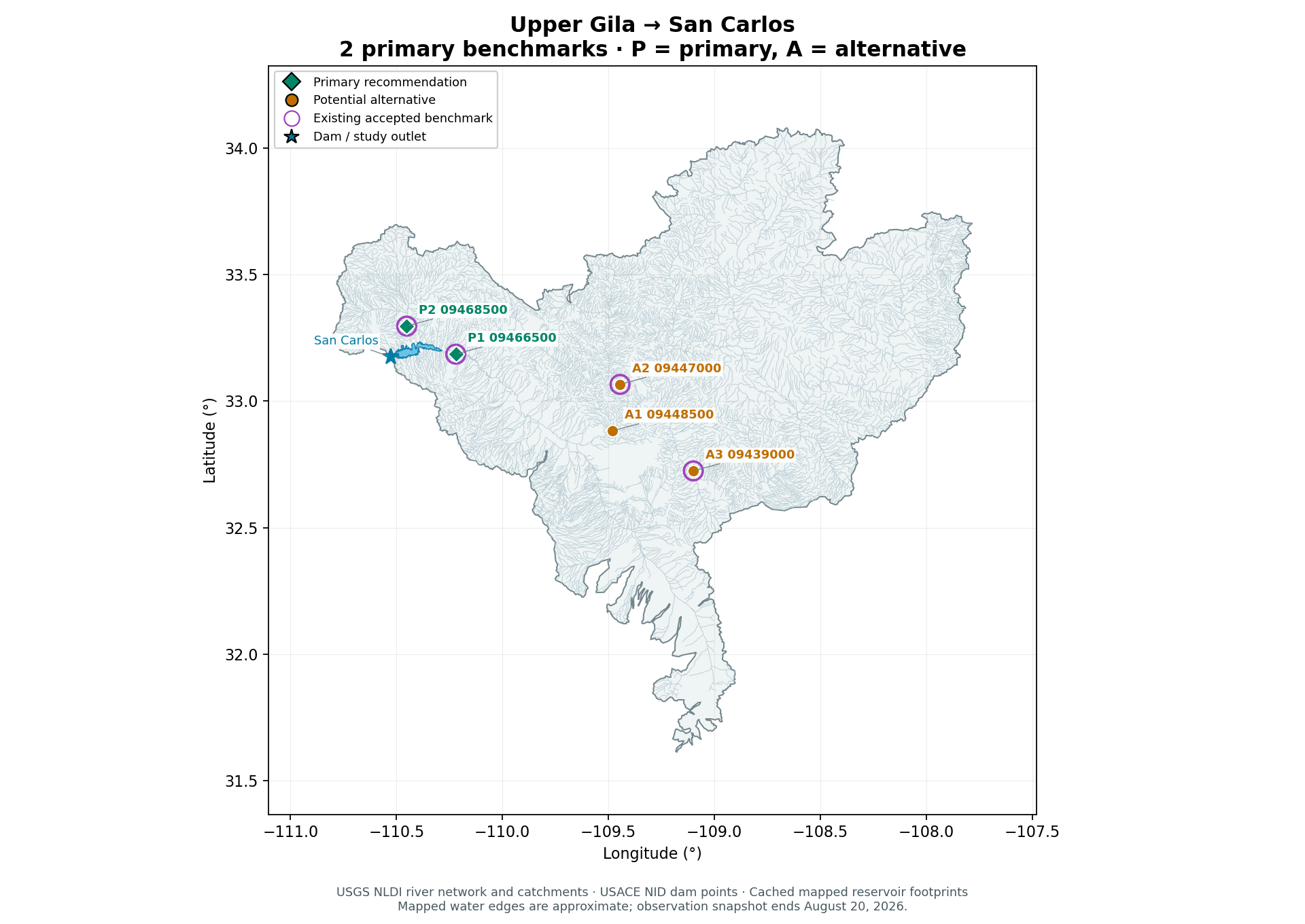
San Carlos Reservoir / Coolidge Dam
Calva measures the principal Gila River inflow and Peridot measures the distinct San Carlos River inflow near the reservoir. These are preferable to a uniform four-gage quota when the question is reservoir inflow. Retain Duncan and Eagle Creek as the existing analyzed diagnostic targets, not as substitutes for either reservoir arm.
| Key | Gage | 2023–24 | 2025–Aug 20, 2026 | Apr–Jul 2025 | Apr–Jul 2026 | Straight-line distances |
|---|---|---|---|---|---|---|
| P1 | USGS-09466500GILA RIVER AT CALVA, AZExisting accepted benchmark | 731/731 | 597/597 | 122/122 | 122/122 | 6.2 km to San Carlos28.7 km to study dam / outlet |
| P2 | USGS-09468500SAN CARLOS RIVER NEAR PERIDOT, AZ.Existing accepted benchmark | 731/731 | 597/597 | 122/122 | 122/122 | 8.2 km to San Carlos15.3 km to study dam / outlet |
| A1 | USGS-09448500GILA RIVER AT HEAD OF SAFFORD VALLEY, NR SOLOMON, | 731/731 | 596/597 | 121/122 | 122/122 | 82.7 km to San Carlos103.0 km to study dam / outlet |
| A2 | USGS-09447000EAGLE CREEK ABOVE PUMPING PLANT, NEAR MORENCI, AZ.Existing accepted benchmark | 731/731 | 597/597 | 122/122 | 122/122 | 79.2 km to San Carlos101.6 km to study dam / outlet |
| A3 | USGS-09439000GILA RIVER AT DUNCAN, AZExisting accepted benchmark | 731/731 | 532/597 | 122/122 | 107/122 | 122.2 km to San Carlos142.4 km to study dam / outlet |
Observed daily means / expected calendar days. P = primary; A = alternative. Purple map rings identify existing accepted benchmarks.
P1 USGS-09466500 · GILA RIVER AT CALVA, AZ Primary
Lowermost long-record upstream Gila gage in the existing 50-station cohort, immediately relevant to San Carlos Reservoir supply.
Represents observed regulated/diverted river discharge, not naturalized runoff or total reservoir inflow. Channel losses and ungaged inflow between the station and reservoir remain outside the gage target.
Usable cached record: 1980-01-01 to 2026-08-20; 17,034 observed days with gaps retained.
Open watershed observations · Source 1 · Source 2 · Source 3
P2 USGS-09468500 · SAN CARLOS RIVER NEAR PERIDOT, AZ. Primary
Captures the other major reservoir inflow branch; a Calva-only benchmark misses this water. The absence of upstream donor gages in the existing source cohort does not mean this station is below San Carlos Dam.
Existing cohort has no verified upstream donor gages for this receiver, so its forecast uses regional information and its permitted own history. Upstream irrigation and Talkalai Reservoir affect the observed flow.
Usable cached record: 1980-01-01 to 2026-08-20; 16,836 observed days with gaps retained.
Open watershed observations · Source 1 · Source 2 · Source 3
A1 USGS-09448500 · GILA RIVER AT HEAD OF SAFFORD VALLEY, NR SOLOMON, Alternative
Strong long-record mainstem alternative farther upstream. Useful for diagnosing Safford Valley diversions and losses before Calva; not a direct replacement for the San Carlos branch.
Usable cached record: 1980-01-01 to 2026-08-20; 17,033 observed days with gaps retained.
A2 USGS-09447000 · EAGLE CREEK ABOVE PUMPING PLANT, NEAR MORENCI, AZ. Alternative
Existing analyzed benchmark and long-record tributary target. Retain for continuity and a different hydrologic response, but it lies substantially farther from San Carlos Reservoir.
Usable cached record: 1980-01-01 to 2026-08-20; 17,034 observed days with gaps retained.
A3 USGS-09439000 · GILA RIVER AT DUNCAN, AZ Alternative
Existing analyzed mainstem benchmark useful for cross-basin continuity and upstream forecast skill. Farther upstream and shorter effective daily record than Calva or Solomon.
Usable cached record: 2003-09-30 to 2026-08-20; 7,930 observed days with gaps retained.
- Both reservoir-focused primary gages are already receivers in the accepted four-gage Upper Gila analyses; no rerun is needed to identify their existing results separately. Do not change the active four-receiver protocol.
Candidates to avoid or qualify
- USGS-09469500: Gila River below Coolidge Dam is a release target, not an upstream San Carlos Reservoir inflow benchmark.
Printable basin map
Salt + Tonto
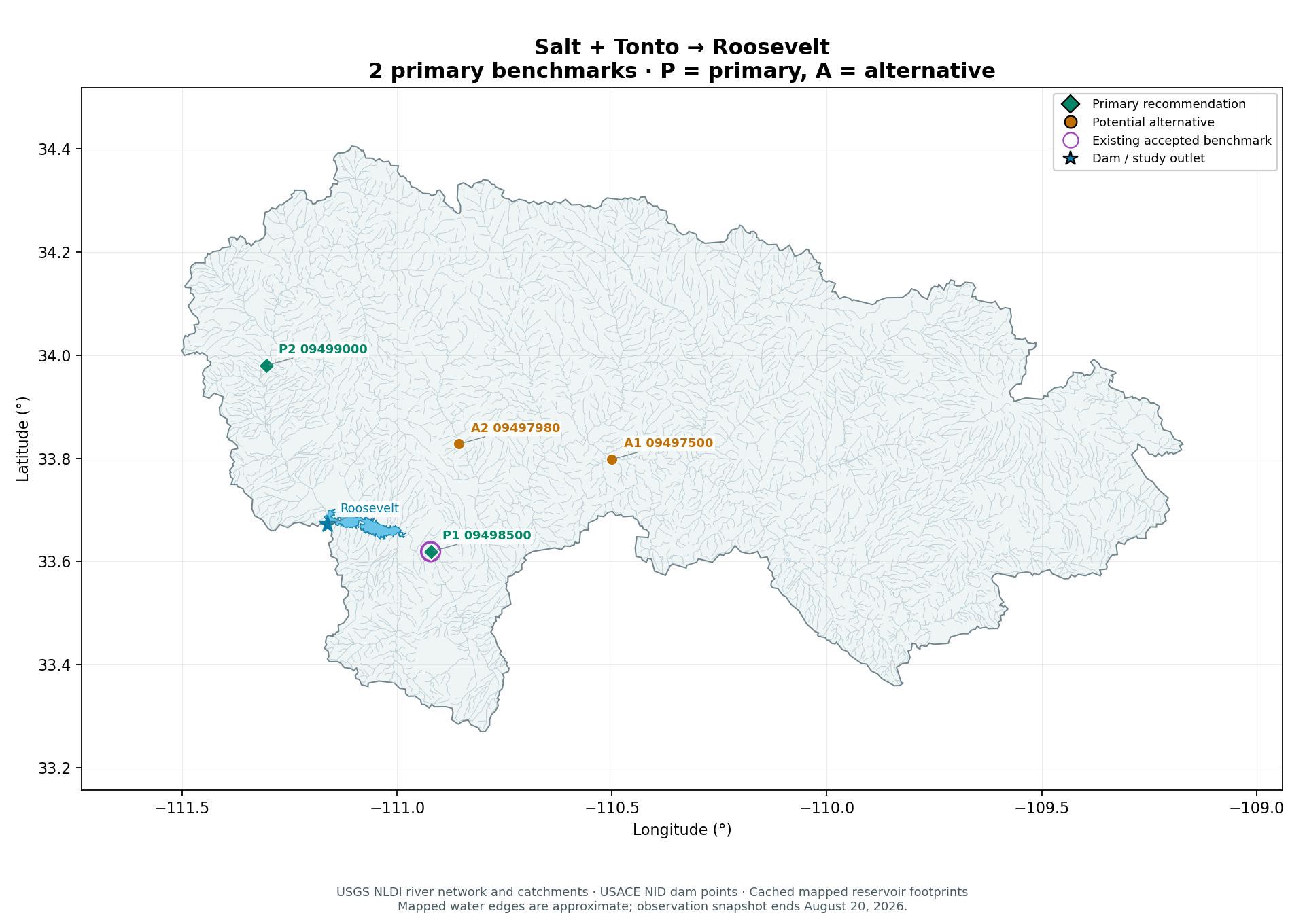
Theodore Roosevelt Lake
Two receivers cover the two distinct large inflow arms of Roosevelt Lake. Keep the authorized one-gage Salt River study unchanged and describe Tonto Creek as the recommended follow-up or alternative; do not silently add a target to the running experiment.
| Key | Gage | 2023–24 | 2025–Aug 20, 2026 | Apr–Jul 2025 | Apr–Jul 2026 | Straight-line distances |
|---|---|---|---|---|---|---|
| P1 | USGS-09498500SALT RIVER NEAR ROOSEVELT, AZExisting accepted benchmark | 731/731 | 596/597 | 121/122 | 122/122 | 6.5 km to Roosevelt22.9 km to study dam / outlet |
| P2 | USGS-09499000TONTO CREEK ABOVE GUN CREEK, NEAR ROOSEVELT, AZ | 731/731 | 597/597 | 122/122 | 122/122 | 34.1 km to Roosevelt36.7 km to study dam / outlet |
| A1 | USGS-09497500SALT RIVER NEAR CHRYSOTILE, AZ | 731/731 | 597/597 | 122/122 | 122/122 | 46.9 km to Roosevelt62.8 km to study dam / outlet |
| A2 | USGS-09497980CHERRY CREEK NEAR GLOBE, AZ | 731/731 | 597/597 | 122/122 | 122/122 | 22.2 km to Roosevelt33.1 km to study dam / outlet |
Observed daily means / expected calendar days. P = primary; A = alternative. Purple map rings identify existing accepted benchmarks.
P1 USGS-09498500 · SALT RIVER NEAR ROOSEVELT, AZ Primary
USACE identifies it just upstream of Theodore Roosevelt Lake; the USGS station description places it seventeen miles upstream of Roosevelt Dam.
One missing cached daily observation on June 3, 2025 prevents a strict complete April–July 2025 seasonal total. This remains a valid daily forecast target with masks retained.
Usable cached record: 1980-01-01 to 2026-08-20; 17,033 observed days with gaps retained.
Open watershed observations · Source 1 · Source 2 · Source 3
P2 USGS-09499000 · TONTO CREEK ABOVE GUN CREEK, NEAR ROOSEVELT, AZ Primary
USACE explicitly identifies this as an upstream Roosevelt Lake station on Tonto Creek. Its separate branch is not measured by the existing Salt River receiver, and its cached 1980–2026 daily series is complete.
There are small irrigation diversions above the station; low-flow and zero-flow behavior differs from the Salt River. Gun Creek and other downstream ungaged drainage are outside the station's discharge.
Usable cached record: 1980-01-01 to 2026-08-20; 17,034 observed days with gaps retained.
Open watershed observations · Source 1 · Source 2 · Source 3
A1 USGS-09497500 · SALT RIVER NEAR CHRYSOTILE, AZ Alternative
Long complete upstream mainstem record is the best fallback/diagnostic Salt target if the Roosevelt gage is unavailable. It misses lower tributaries entering before the primary gage and does not replace Tonto inflow.
Usable cached record: 1980-01-01 to 2026-08-20; 17,034 observed days with gaps retained.
A2 USGS-09497980 · CHERRY CREEK NEAR GLOBE, AZ Alternative
Long complete lower-basin tributary record useful for an expanded diagnostic receiver set; its inflow is already represented in the downstream Salt River target.
Usable cached record: 1980-01-01 to 2026-08-20; 17,034 observed days with gaps retained.
- The current Salt-only receiver analysis remains separate from this proposed two-arm reservoir benchmark. Both targets have 731/731 validation dates; the cached recent counts are 596/597 Salt and 597/597 Tonto.
Candidates to avoid or qualify
- Use the qualifications above when selecting alternatives.
Printable basin map
Upper Little Colorado
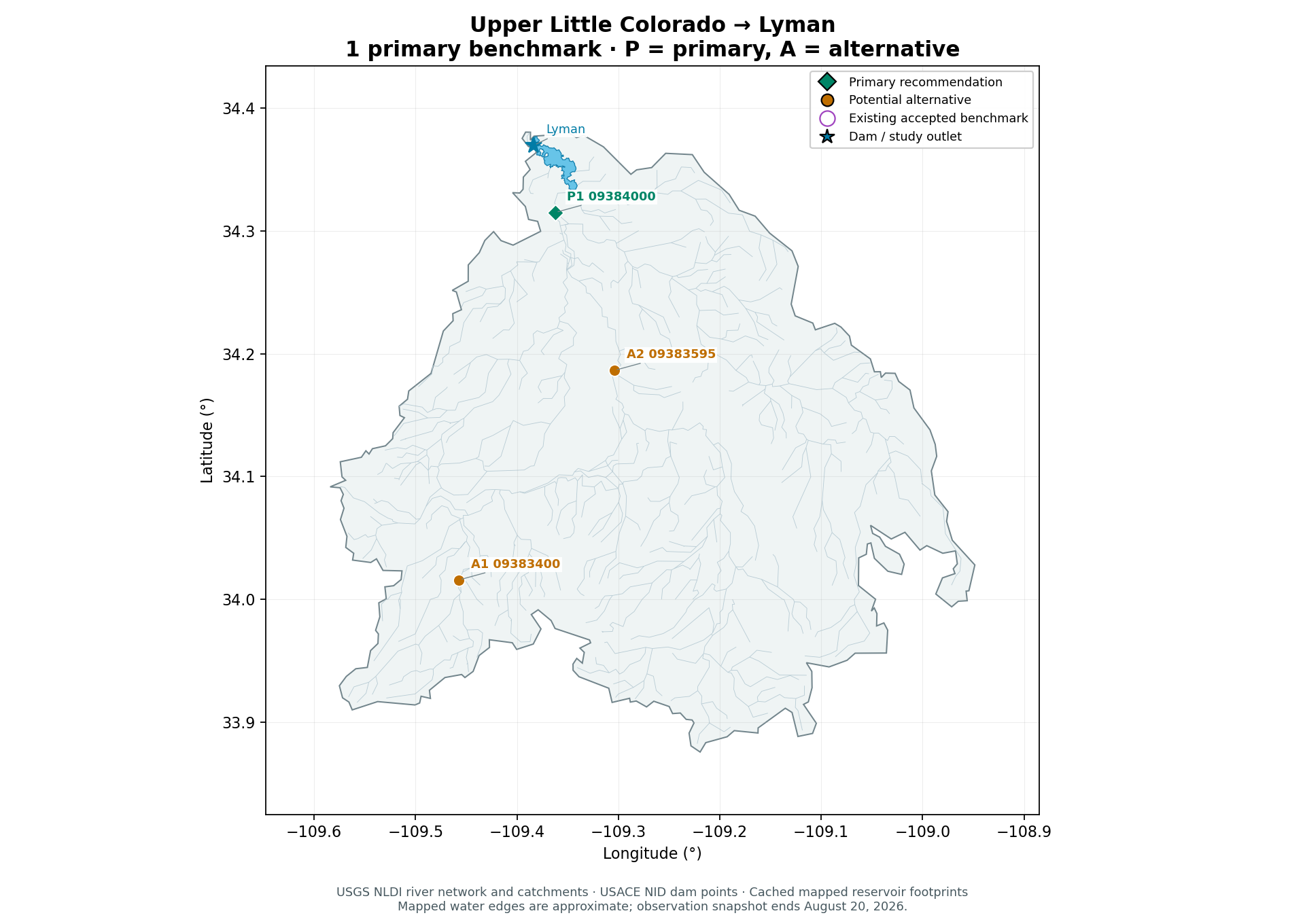
Lyman Lake
Use the long-record gage explicitly above Lyman Lake rather than a larger but largely historical headwater receiver set. One mainstem target is the natural starting point for this small reservoir catchment.
| Key | Gage | 2023–24 | 2025–Aug 20, 2026 | Apr–Jul 2025 | Apr–Jul 2026 | Straight-line distances |
|---|---|---|---|---|---|---|
| P1 | USGS-09384000LITTLE COLORADO R ABV LYMAN LAKE NR ST. JOHNS, AZ | 731/731 | 596/597 | 122/122 | 121/122 | 2.5 km to Lyman6.4 km to study dam / outlet |
| A1 | USGS-09383400LITTLE COLORADO RIVER AT GREER, AZ | 731/731 | 597/597 | 122/122 | 122/122 | 36.9 km to Lyman39.9 km to study dam / outlet |
| A2 | USGS-09383595LITTLE COLORADO R AT WENIMA, NR SPRINGERVILLE, AZ | 0/731 | 0/597 | 0/122 | 0/122 | 16.8 km to Lyman21.6 km to study dam / outlet |
Observed daily means / expected calendar days. P = primary; A = alternative. Purple map rings identify existing accepted benchmarks.
P1 USGS-09384000 · LITTLE COLORADO R ABV LYMAN LAKE NR ST. JOHNS, AZ Primary
USGS places the station six miles upstream of Lyman Dam and identifies it as the river-inflow measurement in a Lyman Lake water budget. The cached 1980–2026 record has only one missing daily target.
Flow is affected by small upstream reservoirs and irrigation diversions; it is not naturalized runoff. USGS historical water-budget work distinguishes ungaged lake inflow and groundwater exchanges from this measured river inflow. The river may have genuine zero-flow days, which must be retained.
Usable cached record: 1980-01-01 to 2026-08-20; 17,033 observed days with gaps retained.
Open watershed observations · Source 1 · Source 2 · Source 3
A1 USGS-09383400 · LITTLE COLORADO RIVER AT GREER, AZ Alternative
Only other strong currently observed natural-channel receiver in the cached catchment. Useful for headwater snowmelt response and a paired upstream comparison, but substantially farther from Lyman and with a discontinuous earlier record.
Usable cached record: 1980-01-01 to 2026-08-20; 7,661 observed days with gaps retained.
A2 USGS-09383595 · LITTLE COLORADO R AT WENIMA, NR SPRINGERVILLE, AZ Alternative
Geographically useful historical mainstem alternative between Springerville and Lyman. Cached observations end in October 2013, so it is a historical benchmark only unless a new source is obtained.
Usable cached record: 2008-08-08 to 2013-10-21; 1,901 observed days with gaps retained.
- Primary has 731/731 validation targets and 596/597 recent targets. Greer has full validation/recent coverage despite its much shorter and interrupted pre-2023 history.
Candidates to avoid or qualify
- USGS-09384600: Lyman Lake station is at the impoundment/spillway and its cached daily-flow observations are confined to 1984–1985; current gage height does not make it a complete recent daily inflow target.
Printable basin map
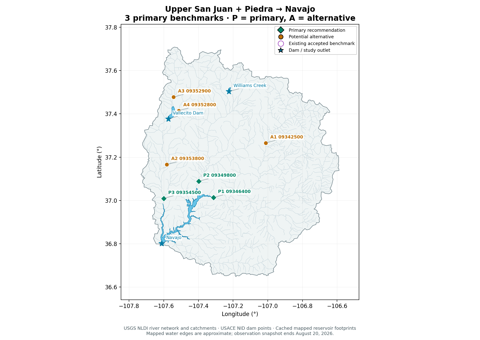
Upper San Juan + Piedra
Navajo Reservoir
Three gages represent the San Juan, Piedra and Los Pinos reservoir-entry branches. Each is close to Navajo and has complete 2023-24 validation and April-July 2025/2026 truth; using fewer would omit a major entry branch.
| Key | Gage | 2023–24 | 2025–Aug 20, 2026 | Apr–Jul 2025 | Apr–Jul 2026 | Straight-line distances |
|---|---|---|---|---|---|---|
| P1 | USGS-09346400SAN JUAN RIVER NEAR CARRACAS, CO. | 731/731 | 566/597 | 122/122 | 122/122 | 0.0 km to Navajo35.6 km to study dam / outlet |
| P2 | USGS-09349800PIEDRA RIVER NEAR ARBOLES, CO. | 731/731 | 559/597 | 122/122 | 122/122 | 3.7 km to Navajo37.1 km to study dam / outlet |
| P3 | USGS-09354500LOS PINOS RIVER AT LA BOCA, CO. | 731/731 | 597/597 | 122/122 | 122/122 | 2.8 km to Navajo23.1 km to study dam / outlet |
| A1 | USGS-09342500SAN JUAN RIVER AT PAGOSA SPRINGS, CO | 731/731 | 568/597 | 122/122 | 122/122 | 38.6 km to Navajo74.2 km to study dam / outlet |
| A2 | USGS-09353800LOS PINOS RIVER NEAR IGNACIO, CO | 731/731 | 597/597 | 122/122 | 122/122 | 19.4 km to Navajo40.6 km to study dam / outlet |
| A3 | USGS-09352900VALLECITO CREEK NEAR BAYFIELD, CO. | 731/731 | 550/597 | 122/122 | 122/122 | 48.5 km to Navajo75.4 km to study dam / outlet |
| A4 | USGS-09352800LOS PINOS R ABV VALLECITO RES NR BAYFIELD, CO | 731/731 | 597/597 | 122/122 | 122/122 | 41.1 km to Navajo68.7 km to study dam / outlet |
Observed daily means / expected calendar days. P = primary; A = alternative. Purple map rings identify existing accepted benchmarks.
P1 USGS-09346400 · SAN JUAN RIVER NEAR CARRACAS, CO. Primary
San Juan mainstem at the head of Navajo; USGS describes the gage as just above the maximum reservoir water surface.
Irrigation and San Juan-Chama transbasin diversions affect natural runoff.
Usable cached record: 1980-01-01 to 2026-08-20; 17,003 observed days with gaps retained.
P2 USGS-09349800 · PIEDRA RIVER NEAR ARBOLES, CO. Primary
Piedra inflow branch, 2.5 miles upstream of Navajo Reservoir according to USGS.
Irrigation diversions; winter estimated/missing readings remain explicit.
Usable cached record: 1980-01-01 to 2026-08-20; 16,996 observed days with gaps retained.
P3 USGS-09354500 · LOS PINOS RIVER AT LA BOCA, CO. Primary
Los Pinos branch, 2 miles upstream of the maximum Navajo Reservoir elevation according to USGS.
Flow regulated by Vallecito 24 miles upstream; Spring Creek joins downstream of gage.
Usable cached record: 1980-01-01 to 2026-08-20; 17,034 observed days with gaps retained.
A1 USGS-09342500 · SAN JUAN RIVER AT PAGOSA SPRINGS, CO Alternative
San Juan at Pagosa Springs provides a long-history upper-mainstem alternative if a more natural headwater target is desired.
Farther upstream and excludes later tributary inflow measured by Carracas.
Usable cached record: 1980-01-01 to 2026-08-20; 17,005 observed days with gaps retained.
A2 USGS-09353800 · LOS PINOS RIVER NEAR IGNACIO, CO Alternative
Los Pinos near Ignacio has complete recent study-window coverage and is an upstream alternative to La Boca.
Less downstream contributing area; still below Vallecito Reservoir.
Usable cached record: 1999-10-01 to 2026-08-20; 9,821 observed days with gaps retained.
A3 USGS-09352900 · VALLECITO CREEK NEAR BAYFIELD, CO. Alternative
Vallecito Creek provides a long-record, relatively natural inflow benchmark for Vallecito Reservoir rather than Navajo.
A different reservoir question; 47 recent missing days but both April-July seasons complete.
Usable cached record: 1980-01-01 to 2026-08-20; 16,987 observed days with gaps retained.
A4 USGS-09352800 · LOS PINOS R ABV VALLECITO RES NR BAYFIELD, CO Alternative
Los Pinos above Vallecito Reservoir is a directly named reservoir inflow with complete recent coverage.
Daily record starts in April 2018, giving much shorter training history than core Navajo gages.
Usable cached record: 2018-04-20 to 2026-08-20; 3,045 observed days with gaps retained.
- Los Pinos at La Boca measures inflow to Navajo but is downstream of Vallecito Reservoir, so reservoir releases and irrigation affect the series.
- Carracas and Piedra have short autumn/winter gaps in 2025-26; no target gap imputation should be used for reported scores.
- These three are not an exact complete Navajo mass balance; ungaged tributaries including Spring Creek below the La Boca gage contribute.
- The Navajo River tributary is included in the main San Juan receiver rather than requiring a fourth target.
Candidates to avoid or qualify
- USGS-09355000: Spring Creek at La Boca represents an additional local branch not measured by Los Pinos. Cached daily observations stop in 2011; not usable as a scored 2025-26 receiver.
Printable basin map
Upper Green
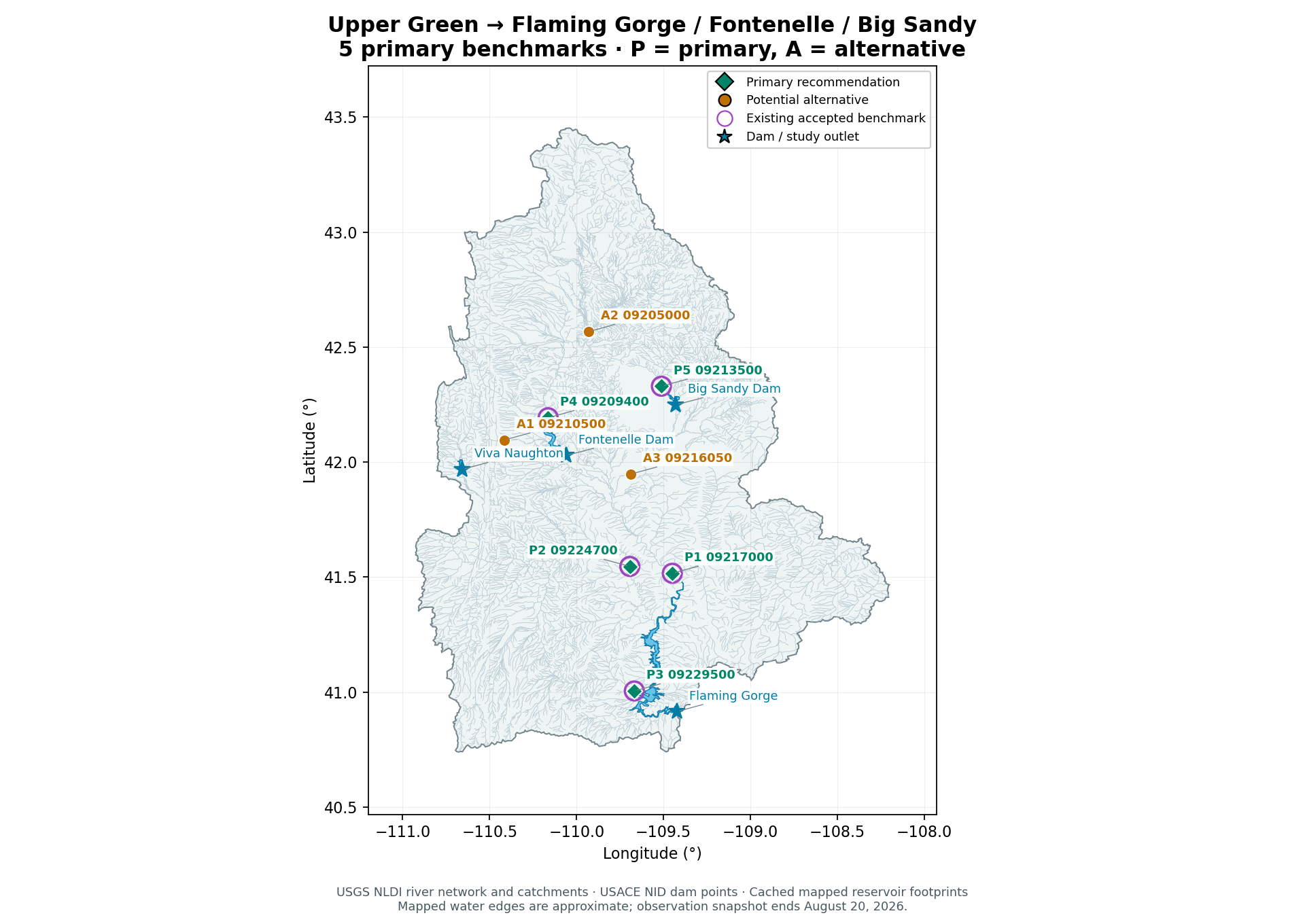
Flaming Gorge; Fontenelle and Big Sandy upstream reservoir checks
Three distinct Flaming Gorge inflow branches plus one Fontenelle inflow and one Big Sandy Reservoir inflow preserve the accepted five while covering two upstream reservoirs. If only Flaming Gorge inflows are the objective, the three-gage core is sufficient for an initial comparison; this is a practical proposal, not an optimized proven minimum.
| Key | Gage | 2023–24 | 2025–Aug 20, 2026 | Apr–Jul 2025 | Apr–Jul 2026 | Straight-line distances |
|---|---|---|---|---|---|---|
| P1 | USGS-09217000GREEN RIVER NEAR GREEN RIVER, WYExisting accepted benchmark | 731/731 | 597/597 | 122/122 | 122/122 | 6.3 km to Flaming Gorge66.9 km to study dam / outlet |
| P2 | USGS-09224700BLACKS FORK NEAR LITTLE AMERICA, WYExisting accepted benchmark | 731/731 | 597/597 | 122/122 | 122/122 | 24.9 km to Flaming Gorge73.8 km to study dam / outlet |
| P3 | USGS-09229500HENRYS FORK NEAR MANILA, UTExisting accepted benchmark | 731/731 | 597/597 | 122/122 | 122/122 | 0.7 km to Flaming Gorge22.9 km to study dam / outlet |
| P4 | USGS-09209400GREEN RIVER NEAR LA BARGE, WYExisting accepted benchmark | 731/731 | 597/597 | 122/122 | 122/122 | 2.3 km to Fontenelle Dam154.9 km to study dam / outlet |
| P5 | USGS-09213500BIG SANDY RIVER NEAR FARSON, WYSeasonal target: winter observations unavailableExisting accepted benchmark | 388/731 | 343/597 | 122/122 | 122/122 | 4.8 km to Big Sandy Dam157.5 km to study dam / outlet |
| A1 | USGS-09210500FONTENELLE C NR HERSCHLER RANCH, NR FONTENELLE, WY | 731/731 | 597/597 | 122/122 | 122/122 | 109.1 km to Flaming Gorge155.2 km to study dam / outlet |
| A2 | USGS-09205000NEW FORK RIVER NEAR BIG PINEY, WY | 731/731 | 597/597 | 122/122 | 122/122 | 129.6 km to Flaming Gorge188.5 km to study dam / outlet |
| A3 | USGS-09216050Big Sandy River at Gasson Bridge, near Eden, WY | 0/731 | 321/597 | 0/122 | 122/122 | 57.9 km to Flaming Gorge116.9 km to study dam / outlet |
Observed daily means / expected calendar days. P = primary; A = alternative. Purple map rings identify existing accepted benchmarks.
P1 USGS-09217000 · GREEN RIVER NEAR GREEN RIVER, WY Primary
Mainstem Green River inflow benchmark nearest the reservoir with long, complete study-window coverage. USGS describes it as 4.0 miles upstream of the reservoir high-water line.
Regulated by Fontenelle and other upstream uses.
Usable cached record: 1980-01-01 to 2026-08-20; 17,034 observed days with gaps retained.
P2 USGS-09224700 · BLACKS FORK NEAR LITTLE AMERICA, WY Primary
Blacks Fork inflow branch; adds a distinct reservoir arm rather than another mainstem station.
Includes irrigation diversions and upstream impoundment effects; physical zeros are valid.
Usable cached record: 1980-01-01 to 2026-08-20; 17,034 observed days with gaps retained.
P3 USGS-09229500 · HENRYS FORK NEAR MANILA, UT Primary
Henrys Fork inflow branch; USGS places it about 1.3 miles upstream of the normal reservoir high-water line.
Irrigation diversions and the historical 1993-2001 record gap.
Usable cached record: 1980-01-01 to 2026-08-20; 14,264 observed days with gaps retained.
P4 USGS-09209400 · GREEN RIVER NEAR LA BARGE, WY Primary
Accepted target and a direct upstream indicator for Fontenelle; USBR explicitly labels this station upstream.
Nested within the downstream Green River target; not an independent Flaming Gorge inflow to sum.
Usable cached record: 1980-01-01 to 2026-08-20; 17,034 observed days with gaps retained.
P5 USGS-09213500 · BIG SANDY RIVER NEAR FARSON, WY Primary
Accepted target immediately upstream of Big Sandy Reservoir, providing an additional local reservoir benchmark.
Seasonal operation gives missing winter targets; evaluate April-July and daily finite-pair coverage explicitly.
Usable cached record: 1980-04-01 to 2026-08-20; 8,555 observed days with gaps retained.
A1 USGS-09210500 · FONTENELLE C NR HERSCHLER RANCH, NR FONTENELLE, WY Alternative
Fontenelle Creek tributary upstream of the reservoir, suitable as a tributary addition to La Barge.
Smaller incremental reservoir tributary rather than a substitute for mainstem Green River.
Usable cached record: 1980-01-01 to 2026-08-20; 17,034 observed days with gaps retained.
A2 USGS-09205000 · NEW FORK RIVER NEAR BIG PINEY, WY Alternative
New Fork River near Big Piney: complete long record, a major upstream branch and clean addition for snowmelt-transfer testing.
Farther from the reservoir; its flow is already included in La Barge.
Usable cached record: 1980-01-01 to 2026-08-20; 17,034 observed days with gaps retained.
A3 USGS-09216050 · Big Sandy River at Gasson Bridge, near Eden, WY Alternative
Lower Big Sandy target closer to its Green River confluence.
No 2023-24 validation truth or April-July 2025 truth in the cache; cannot replace Farson in a matched current benchmark.
Usable cached record: 1980-01-01 to 2026-08-20; 10,093 observed days with gaps retained.
- Green River near Green River is upstream of Flaming Gorge but downstream of Fontenelle, so its flow includes reservoir operation effects.
- The La Barge and Green River targets have nested drainage areas and must not be summed as separate inflows.
- Farson is seasonally operated; do not invent winter target measurements. All five have complete April-July 2025 and 2026 records.
- Henrys Fork has a long 1993-2001 historical gap; use masked training and state its effective training coverage.
- A gage sum is not identical to reservoir balance inflow; ungaged contributions, routing and changing storage remain.
Candidates to avoid or qualify
- USGS-09211200: Use as a separate observed release/operations input or control, not an upstream inflow receiver for Fontenelle. Below Fontenelle Dam; unsuitable as the requested upstream Fontenelle benchmark.
Printable basin map
Upper Gunnison
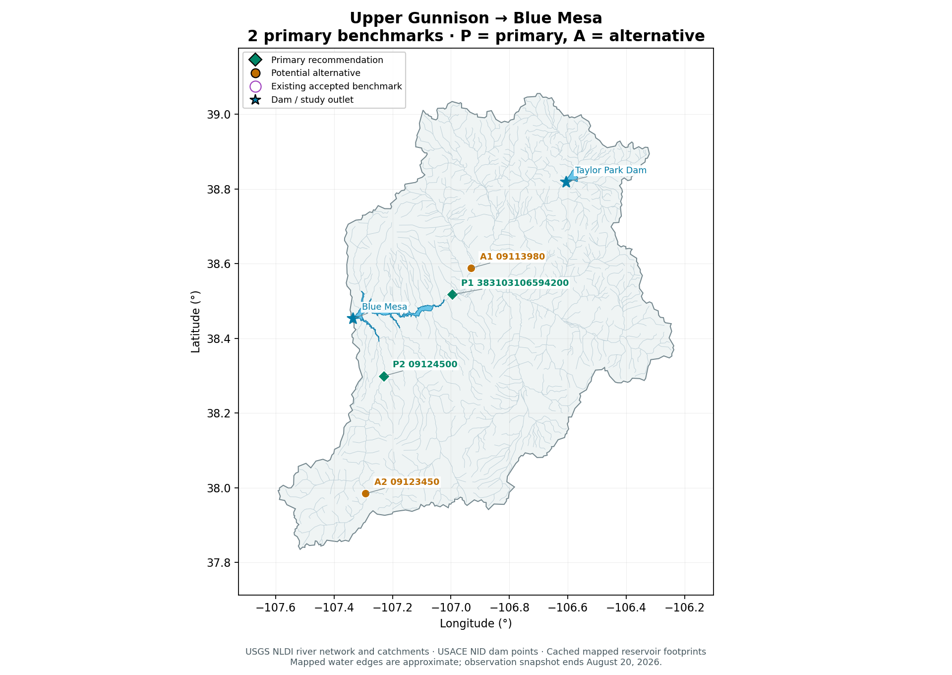
Blue Mesa Reservoir
Two primary targets cover the combined Gunnison-and-Tomichi inflow at County Road 32 and the separate Lake Fork reservoir arm. County Road 32 is the direct combined-flow benchmark; its cached measured record starts 2017-11-16, so matched hindcasts must respect that shorter coverage. This is a practical reservoir-oriented selection, not a statistically optimized minimum.
| Key | Gage | 2023–24 | 2025–Aug 20, 2026 | Apr–Jul 2025 | Apr–Jul 2026 | Straight-line distances |
|---|---|---|---|---|---|---|
| P1 | USGS-383103106594200GUNNISON RIVER AT CNTY RD 32 BELOW GUNNISON, CO | 731/731 | 597/597 | 122/122 | 122/122 | 2.8 km to Blue Mesa30.3 km to study dam / outlet |
| P2 | USGS-09124500LAKE FORK AT GATEVIEW, CO. | 731/731 | 597/597 | 122/122 | 122/122 | 10.5 km to Blue Mesa19.4 km to study dam / outlet |
| A1 | USGS-09113980OHIO CREEK ABOVE MOUTH NR GUNNISON, CO | 731/731 | 597/597 | 122/122 | 122/122 | 12.4 km to Blue Mesa38.1 km to study dam / outlet |
| A2 | USGS-09123450LAKE FORK BLW LAKE SAN CRISTOBAL NR LAKE CITY, CO | 731/731 | 597/597 | 122/122 | 122/122 | 45.8 km to Blue Mesa52.3 km to study dam / outlet |
Observed daily means / expected calendar days. P = primary; A = alternative. Purple map rings identify existing accepted benchmarks.
P1 USGS-383103106594200 · GUNNISON RIVER AT CNTY RD 32 BELOW GUNNISON, CO Primary
Direct measured combined Gunnison-and-Tomichi inflow benchmark downstream of their confluence and closer to Blue Mesa; replaces selection of the two separate upstream branch gages.
Actual daily discharge starts 2017-11-16 in cache, limiting long hindcasts; use the measured record without substituting an earlier upstream-gage reconstruction.
Usable cached record: 2017-11-16 to 2026-08-20; 3,200 observed days with gaps retained.
P2 USGS-09124500 · LAKE FORK AT GATEVIEW, CO. Primary
Long-record Lake Fork outlet on the separate southern Blue Mesa arm; USGS station description places it 6.3 miles upstream of the reservoir waterline at stated elevation.
Historical 6.3-mile distance is referenced to the stated reservoir waterline, not a current shoreline survey; intervening inflow is ungaged.
Usable cached record: 1980-01-01 to 2026-08-20; 17,034 observed days with gaps retained.
A1 USGS-09113980 · OHIO CREEK ABOVE MOUTH NR GUNNISON, CO Alternative
Ohio Creek above mouth: complete recent record and a distinct upstream sub-basin for diagnostics if additional targets are useful.
Further upstream and nested inside the combined County Road 32 catchment; not needed in the minimum reservoir-oriented set.
Usable cached record: 1998-12-04 to 2026-08-20; 10,122 observed days with gaps retained.
A2 USGS-09123450 · LAKE FORK BLW LAKE SAN CRISTOBAL NR LAKE CITY, CO Alternative
Lake Fork below Lake San Cristobal provides a recent complete upstream fallback on the Lake Fork branch.
Starts 2012-11-08; farther from Blue Mesa and does not include all downstream Lake Fork tributaries.
Usable cached record: 2012-11-08 to 2026-08-20; 5,034 observed days with gaps retained.
- The upstream Gunnison near Gunnison and Tomichi at Gunnison gages are no longer selected benchmarks; their measured records remain available for the Others view. Do not add their nested discharges to the combined County Road 32 measurement when estimating total inflow.
- The two primary gages do not measure all Blue Mesa inflow: Cebolla Creek, ungaged tributaries, intervening runoff and diversions remain.
- The Gunnison branch includes upstream Taylor Park regulation; these are observed-flow targets, not naturalized flow.
Candidates to avoid or qualify
- USGS-09121800: Cebolla is a physically relevant separate inflow but the cached 1980-2026Aug20 window has no usable daily discharge. No truth in the current analysis period; do not present it as a current ready benchmark.
- USGS-09114520: Gunnison whitewater park is an upstream mainstem site with a seasonal/shorter record: only92/122 April–July days in each2025 and2026. It does not replace the combined Gunnison-and-Tomichi benchmark at County Road 32.
Printable basin map
Blue River
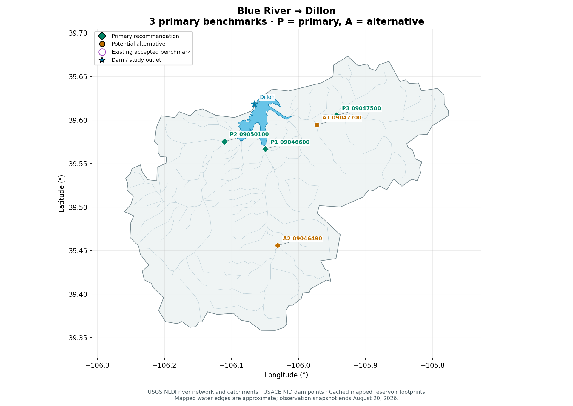
Dillon Reservoir
One target for each of the three principal reservoir inflow branches: Blue River, Tenmile Creek and Snake River. Blue is ready for year-round scoring; Tenmile has winter gaps and Snake is a seasonal target, so the three-target set is especially appropriate for April-July runoff comparisons.
| Key | Gage | 2023–24 | 2025–Aug 20, 2026 | Apr–Jul 2025 | Apr–Jul 2026 | Straight-line distances |
|---|---|---|---|---|---|---|
| P1 | USGS-09046600BLUE RIVER NEAR DILLON, CO | 731/731 | 597/597 | 122/122 | 122/122 | 0.4 km to Dillon5.9 km to study dam / outlet |
| P2 | USGS-09050100TENMILE CREEK BL NORTH TENMILE C, AT FRISCO, CO. | 731/731 | 545/597 | 122/122 | 122/122 | 1.7 km to Dillon6.2 km to study dam / outlet |
| P3 | USGS-09047500SNAKE RIVER NEAR MONTEZUMA, COSeasonal target: winter observations unavailable | 428/731 | 356/597 | 122/122 | 122/122 | 5.7 km to Dillon10.6 km to study dam / outlet |
| A1 | USGS-09047700KEYSTONE GULCH NEAR DILLON, CO. | 731/731 | 575/597 | 122/122 | 122/122 | 3.4 km to Dillon8.4 km to study dam / outlet |
| A2 | USGS-09046490BLUE RIVER AT BLUE RIVER, CO. | 731/731 | 597/597 | 122/122 | 122/122 | 12.9 km to Dillon18.3 km to study dam / outlet |
Observed daily means / expected calendar days. P = primary; A = alternative. Purple map rings identify existing accepted benchmarks.
P1 USGS-09046600 · BLUE RIVER NEAR DILLON, CO Primary
Blue River near Dillon is the near-reservoir mainstem inflow with complete daily cached record from 1980 through August 20, 2026.
Observed inflow reflects upstream diversions; retain as measured physical flow.
Usable cached record: 1980-01-01 to 2026-08-20; 17,034 observed days with gaps retained.
P2 USGS-09050100 · TENMILE CREEK BL NORTH TENMILE C, AT FRISCO, CO. Primary
Tenmile Creek below North Tenmile at Frisco represents the independent western reservoir inflow arm, with complete April-July2025/2026 truth.
52 recent winter days absent; historical USGS metadata notes upstream small diversions and transbasin diversion from Robinson Reservoir.
Usable cached record: 1980-01-01 to 2026-08-20; 16,982 observed days with gaps retained.
P3 USGS-09047500 · SNAKE RIVER NEAR MONTEZUMA, CO Primary
Snake River near Montezuma represents the third principal inflow branch with complete April-July2025/2026 truth.
Seasonal record:428/731 validation days,356/597 recent days. No recent Nov-Mar truth. Upstream of some Snake-arm tributaries; not complete total arm inflow.
Usable cached record: 1980-01-01 to 2026-08-20; 13,834 observed days with gaps retained.
A1 USGS-09047700 · KEYSTONE GULCH NEAR DILLON, CO. Alternative
Keystone Gulch near Dillon: long-record separate tributary in the Snake arm; can complement the upstream Snake gage or extend comparisons when year-round labels are needed.
Only a small tributary, not a replacement for total Snake flow;22 recent winter days absent.
Usable cached record: 1980-01-01 to 2026-08-20; 17,012 observed days with gaps retained.
A2 USGS-09046490 · BLUE RIVER AT BLUE RIVER, CO. Alternative
Blue River at Blue River offers complete recent daily data as a mainstem upstream fallback.
Farther from Dillon and nested within09046600; using both as outputs adds redundancy.
Usable cached record: 1983-10-01 to 2026-08-20; 15,665 observed days with gaps retained.
- Snake River near Montezuma has no usable cached Nov-Mar daily discharge in the recent window, yet complete April-July2025 and2026 records. Do not invent winter truth; either mask those targets or retain Snake only in seasonal scoring.
- Tenmile has 52 missing recent days, all in winter/early spring, and complete April-July2025/2026.
- The Snake gage does not cover every downstream Snake tributary. Keystone Gulch is a useful optional addition or predictor, not a substitute measuring the full Snake arm.
- Transbasin and municipal/irrigation diversions affect observed flow; reservoir supply is not identical to natural runoff.
Candidates to avoid or qualify
- USGS-09041900: Monte Cristo diversion is an operational diversion measurement. Not a reservoir-inflow stream benchmark; no April–July2026 truth in current cache.
- USGS-09044300: Bemrose-Hoosier diversion is an operational diversion measurement. Not a reservoir-inflow stream benchmark; only64/122 April–July2026 days.
- USGS-09044800: McCullough-Spruce-Crystal diversion is an operational diversion measurement. Not a reservoir-inflow stream benchmark; no April–July2026 truth in current cache.
Printable basin map
Yampa
Deerlodge Park river outlet; Stagecoach and Elkhead reservoir alternatives
Use Deerlodge Park as the sole primary basin-outlet target downstream of the Yampa and Little Snake confluence, preserving the existing catchment definition. Four alternatives remain optional context for reservoir-specific or upstream comparisons; they are not additional primary benchmark targets.
| Key | Gage | 2023–24 | 2025–Aug 20, 2026 | Apr–Jul 2025 | Apr–Jul 2026 | Straight-line distances |
|---|---|---|---|---|---|---|
| P1 | USGS-09260050YAMPA RIVER AT DEERLODGE PARK, CO | 731/731 | 578/597 | 122/122 | 122/122 | River outlet target0.0 km to study dam / outlet |
| A1 | USGS-09237450YAMPA RIVER ABOVE STAGECOACH RESERVOIR, CO | 731/731 | 596/597 | 122/122 | 122/122 | 1.3 km to Stagecoach139.9 km to study dam / outlet |
| A2 | USGS-09246200ELKHEAD CREEK ABOVE LONG GULCH, NEAR HAYDEN, CO | 731/731 | 560/597 | 122/122 | 105/122 | 0.9 km to Elkhead Creek103.0 km to study dam / outlet |
| A3 | USGS-09239500YAMPA RIVER AT STEAMBOAT SPRINGS, CO | 731/731 | 597/597 | 122/122 | 122/122 | River outlet target143.2 km to study dam / outlet |
| A4 | USGS-09242500ELK RIVER NEAR MILNER, CO. | 731/731 | 597/597 | 122/122 | 122/122 | River outlet target133.1 km to study dam / outlet |
Observed daily means / expected calendar days. P = primary; A = alternative. Purple map rings identify existing accepted benchmarks.
P1 USGS-09260050 · YAMPA RIVER AT DEERLODGE PARK, CO Primary
Downstream basin-outlet receiver after the Little Snake joins the Yampa; maintains the existing catchment definition.
River outlet, not reservoir; some winter observations missing.
Usable cached record: 1982-10-01 to 2026-08-20; 15,280 observed days with gaps retained.
A1 USGS-09237450 · YAMPA RIVER ABOVE STAGECOACH RESERVOIR, CO Alternative
Yampa immediately above Stagecoach Reservoir is the strongest alternative if reservoir-adjacent inflow is the main objective.
Smaller headwater reservoir question; daily record begins October 1988.
Usable cached record: 1988-10-01 to 2026-08-20; 13,837 observed days with gaps retained.
A2 USGS-09246200 · ELKHEAD CREEK ABOVE LONG GULCH, NEAR HAYDEN, CO Alternative
Elkhead Creek above Long Gulch is upstream of Elkhead Reservoir, verified by the USGS reservoir study.
Discharge stops July 14, 2026 in the current snapshot, leaving 17 missing April-July days and 37 recent missing days.
Usable cached record: 1995-08-10 to 2026-07-14; 11,297 observed days with gaps retained.
A3 USGS-09239500 · YAMPA RIVER AT STEAMBOAT SPRINGS, CO Alternative
Yampa at Steamboat Springs has complete recent data and long history.
Farther from the outlet and downstream of Stagecoach; use for headwater comparison, not Stagecoach inflow.
Usable cached record: 1980-01-01 to 2026-08-20; 17,034 observed days with gaps retained.
A4 USGS-09242500 · ELK RIVER NEAR MILNER, CO. Alternative
Elk River near Milner provides a distinct snowmelt tributary with complete recent coverage.
Upstream branch, not a reservoir-adjacent or basin-total receiver.
Usable cached record: 1990-04-01 to 2026-08-20; 12,627 observed days with gaps retained.
- Yampa is the explicit exception to the reservoir-outlet requirement: the existing study is delineated at Deerlodge Park.
- Maybell and Little Snake near Lily are no longer selected benchmarks; their measured records remain in the source datasets. Their upstream drainage overlaps Deerlodge and must not be summed with it.
- Maybell meets the current Others coverage screen; Little Snake near Lily does not because its July 15-24, 2026 gap exceeds the seven-day limit.
- Deerlodge has winter gaps but complete April-July 2025 and 2026 truth.
- Stagecoach is a directly measured reservoir inflow and has strong recent coverage, but would test a smaller headwater reservoir instead of the existing basin outlet.
- Elkhead upstream-gage discharge ends July 14, 2026 in the current cache; its remaining dates must stay missing.
Candidates to avoid or qualify
- Use the qualifications above when selecting alternatives.
Printable basin map
Dolores
McPhee Reservoir
Use Dolores River at Dolores as the sole primary near-reservoir mainstem target for McPhee Reservoir. It covers the dominant river inflow with complete cached daily observations from 1980 through August 20, 2026, but does not measure all reservoir inflow. Dolores below Rico remains an optional upstream comparison rather than an additional primary benchmark.
| Key | Gage | 2023–24 | 2025–Aug 20, 2026 | Apr–Jul 2025 | Apr–Jul 2026 | Straight-line distances |
|---|---|---|---|---|---|---|
| P1 | USGS-09166500DOLORES RIVER AT DOLORES, CO. | 731/731 | 597/597 | 122/122 | 122/122 | 0.3 km to McPhee13.4 km to study dam / outlet |
| A1 | USGS-09165000DOLORES RIVER BELOW RICO, CO. | 731/731 | 597/597 | 122/122 | 122/122 | 36.9 km to McPhee45.6 km to study dam / outlet |
Observed daily means / expected calendar days. P = primary; A = alternative. Purple map rings identify existing accepted benchmarks.
P1 USGS-09166500 · DOLORES RIVER AT DOLORES, CO. Primary
Dolores River at Dolores is the near-reservoir dominant mainstem inflow; complete daily cache1980-2026Aug20.
Historical USGS station location is upstream of Lost Canyon; this mainstem target omits that separate contribution and does not represent total McPhee inflow.
Usable cached record: 1980-01-01 to 2026-08-20; 17,034 observed days with gaps retained.
A1 USGS-09165000 · DOLORES RIVER BELOW RICO, CO. Alternative
Dolores below Rico is the stronger historical upstream alternative and a useful snowmelt-process/control target.
Farther upstream and nested within Dolores at Dolores; it omits important downstream catchment contributions.
Usable cached record: 1980-01-01 to 2026-08-20; 16,304 observed days with gaps retained.
- Lost Canyon is no longer a selected benchmark and meets the current Others coverage screen. Its original observations remain unchanged, including 5262 genuine zero-flow days in the cached 1984-2026 record; retain zeros and interpret relative metrics carefully near zero.
- Dolores at Dolores is a measured regulated/diverted river, not naturalized inflow; historical USGS notes Ground Hog Reservoir and irrigation diversions upstream.
- The selected mainstem target does not cover all McPhee inflow, including Lost Canyon; the Reclamation operations chart explicitly has a residual Other Inflow component.
Candidates to avoid or qualify
- USGS-09167450: Plateau Creek near mouth is geographically relevant. Only365 usable days1982-10-01 to1983-09-30 and no current evaluation truth; historical case only.
Printable basin map
How to use these benchmarks
- Forecast measured physical discharge at each gage. Reservoir inflow requires a separate water balance and routing analysis, including ungaged drainage.
- Do not add nested gages as independent inflows: Deerlodge contains its upstream branches, County Road 32 combines Gunnison and Tomichi, and La Barge is upstream of Green River near Green River.
- Receiver histories may be used only through each forecast’s observation cutoff. Lock new receiver sets and evaluate multiple historical years before comparing model skill.
- Keep genuine zeros and missing-data masks. Snake near Montezuma and Farson need seasonal scoring; gaps must not become invented target truth.
- Strict April–July volume scoring is unavailable for incomplete seasons, including Salt River in 2025 and Little Snake near Lily in 2026.
This document proposes receiver choices and does not fit new models or claim new forecast performance.